
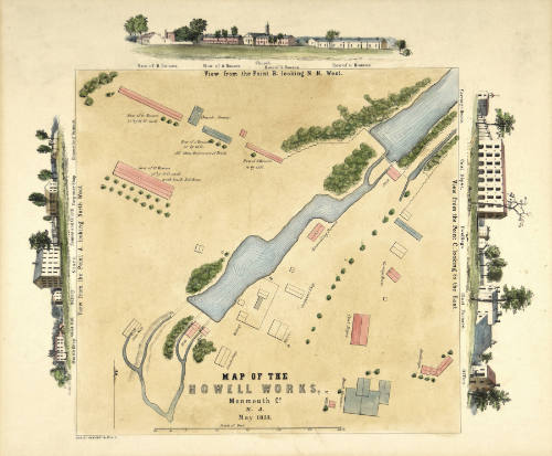
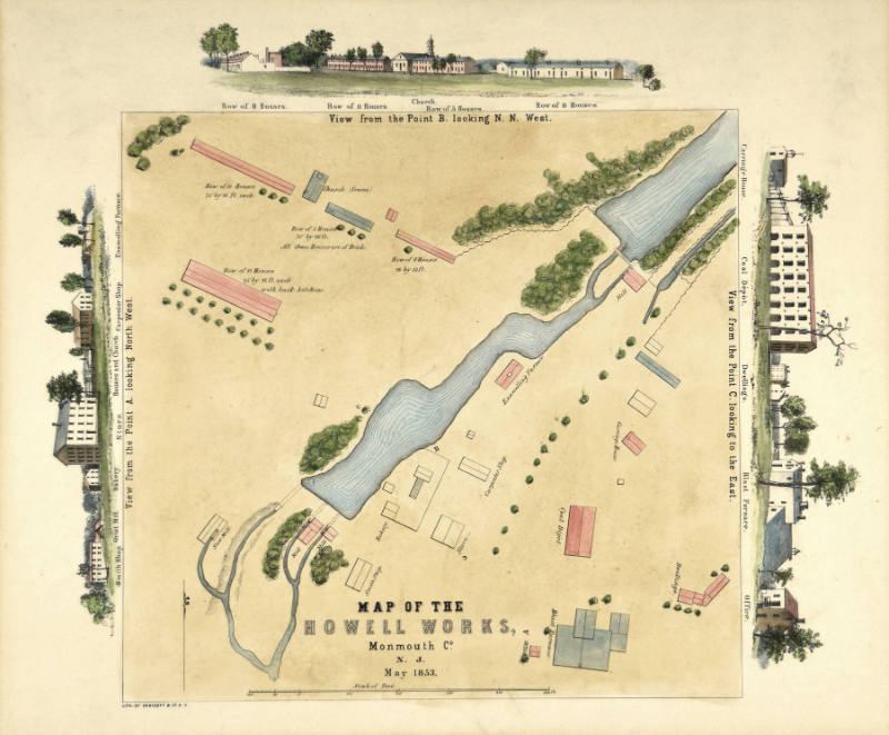
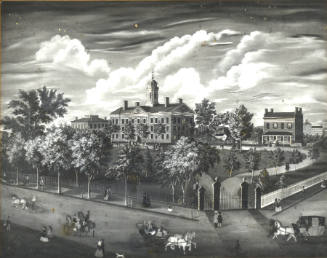
Map of the Howell Works, Monmouth County
Publisher
Endicott & Co.
Period1853
MediumLithograph on paper with color added
Dimensions18 × 22 in. (45.7 × 55.9 cm)
InscribedInscribed lower center, "MAP OF THE / HOWELL WORKS, / Monmouth Co. / N. J. / May 1853."
SignedSigned lower left, "LITH. OF ENDICOTT & CO N. Y."
ClassificationsPrints
Credit LineGift of the Estate of Anne Jackson Riker, 1983
Object number1983.9.1
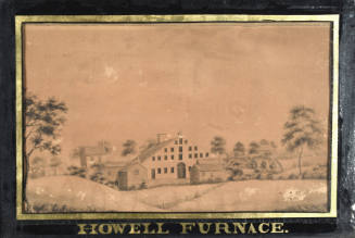
DescriptionThe center of the lithograph contains a very detailed map of the Howell Iron Works located in Howell Township, Monmouth County. A stream impounded by two dams runs from northwest to southeast diagonally across the map. Twenty-seven buildings are depicted, including the blast furnace, coal depot, office, store, carpenter shop, enamelling furnace, carriage house, dwellings, bakery, and smith shop southeast of the stream, four grist and saw mills on millraces originating at the two dams, then four ranges of houses and a frame church northwest of the stream. These nineteen buildings are all titled on the map, eight others not being identified. Three vignettes at the top and sides of the map depict the appearance of the buildings from three vantage points lettered A, B, and C and marked on the map. The views are identified by letter and compass direction, with the structures again named. Hand coloring has been added to the map and vignettes. Buildings have been colored red or blue. Water has been picked out in blue, and trees in green. The background of the map is light tan.Curatorial RemarksThe 1853 lithographed map with vignettes of the Howell Works provides an extremely accurate view of a New Jersey bog iron operation that peaked before the financial panic of 1837. Even though the ironworks had been out of production for seven years by the time the map was commissioned, all of its essential structures including workers' housing remained intact. By 1900, many buildings had started to disappear. Today, only thirteen of them shown on the map still stand.NotesWhat became the Howell Works site in Wall Township, Monmouth County, had been an iron producing location since about 1803. First known as Williamsburg Forge, it was succeeded by the Monmouth Furnace by 1812. The operation and 5,000 acres of land were purchased for $19,000 in 1822 by James P. Allaire (1785 - 1858) of New York, who named it Howell Works to distinguish it from his Allaire Iron Works in New York City. During the next fifteen years, Allaire intensely developed the ironworks. He expanded production of pig iron and cast items, and also replaced many of the existing wooden buildings and mills with large and sturdy brick structures. To overcome the isolation of the village, Allaire created a self-sufficient community that included a carpenter shop, blacksmith shop, bakery, grist mill, saw mills, school, church, post office, and apothecary shop. By 1836, more than 300 people lived and worked at the Howell Works, which then consisted of at least 27 buildings. Iron production ceased in 1846, paralleling the decline of other bog iron furnaces in New Jersey. James P. Allaire lost control of his works in New York in 1850. He then retired and spent his remaining years at the Howell Works with his second wife Calicia and young son Hal (1847 - 1901). In the early 1850s, Allaire contemplated selling the entire property, which then amounted to 7,000 acres. He whitewashed the soot-covered buildings, undertook various landscaping projects, and commissioned this 1853 map of the village. The sale never materialized, and James P. Allaire died there on 20 May 1858. Today, Allaire Village, part of a 3,200 acre state park, is operated as a historic site by Historic Allaire Inc. Thirteen structures remain of those depicted on the survey, including the blast furnace, store, bakery, church, blacksmith shop, carpentry shop, enamelling furnace, and the Allaire family residence.
Collections
Unknown Artist
Alfred T. Bricher
Howell Iron Works
Elizabeth A. Leonard
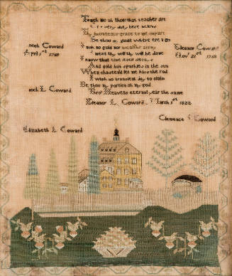
Eleanor L. Coward
Mary Ann Van Schoick
Henry Thomas Gulick
Franklin Patterson
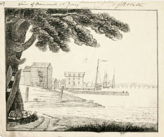
Archibald Robertson